| Grassland fires, 07-Sep-00 | |
| These images of northeastern South Africa, near Kruger National Park, were acquired on September 7, 2000. The left image shows an 85-kilometer wide x 200-kilometer long area captured by MISR's aftward- viewing 45-degree camera. At lower left are the Drakensberg Mountains; to the east of this range a large burn scar with thin smoke plumes from still-smoldering fires is visible. Near the top of the image another large burn scar with an open-pit mine at its western edge can be seen. Other burn scars are scattered throughout the image. Just above the center of the lefthand image is a polygonal burn scar with a set of smoke plumes from actively burning fires at its southwestern tip. The righthand image, which is a "zoomed-in" view of the area, was acquired almost simultaneously by MISR's airborne counterpart, AirMISR, aboard a NASA ER-2 high-altitude aircraft. AirMISR contains a single camera that rotates to different view angles; when this image was acquired the camera was pointed straight downward. Because the ER-2 aircraft flies at an altitude of 20 kilometers, whereas the Terra spacecraft orbits the Earth 700 kilometers above the ground, the AirMISR image has 35 times finer spatial resolution. The AirMISR image covers about 9 kilometers x 9 kilometers. Unlike the MISR view, the AirMISR data are in "raw" form and processing to remove radiometric and geometric distortions has not yet been performed. Fires such as those shown in the images are deliberately set to burn off dry vegetation, and constitute a widespread agricultural practice in many parts of Africa. |  |
| Kruger National Park, June - September | |
| This triplet of color images from the MISR AF camera(26-degree forward view) includes data acquired on June 3, August 22, and September 7 (Terra orbits 2446, 3611, and 3844 respectively). The area is in the Transvaal region of South Africa, southwest of Kruger National Park. The yellowing of the vegetation with time is apparent, as well as the increased prevalence of burn scars. Some scattered smoke plumes are visible as well. | 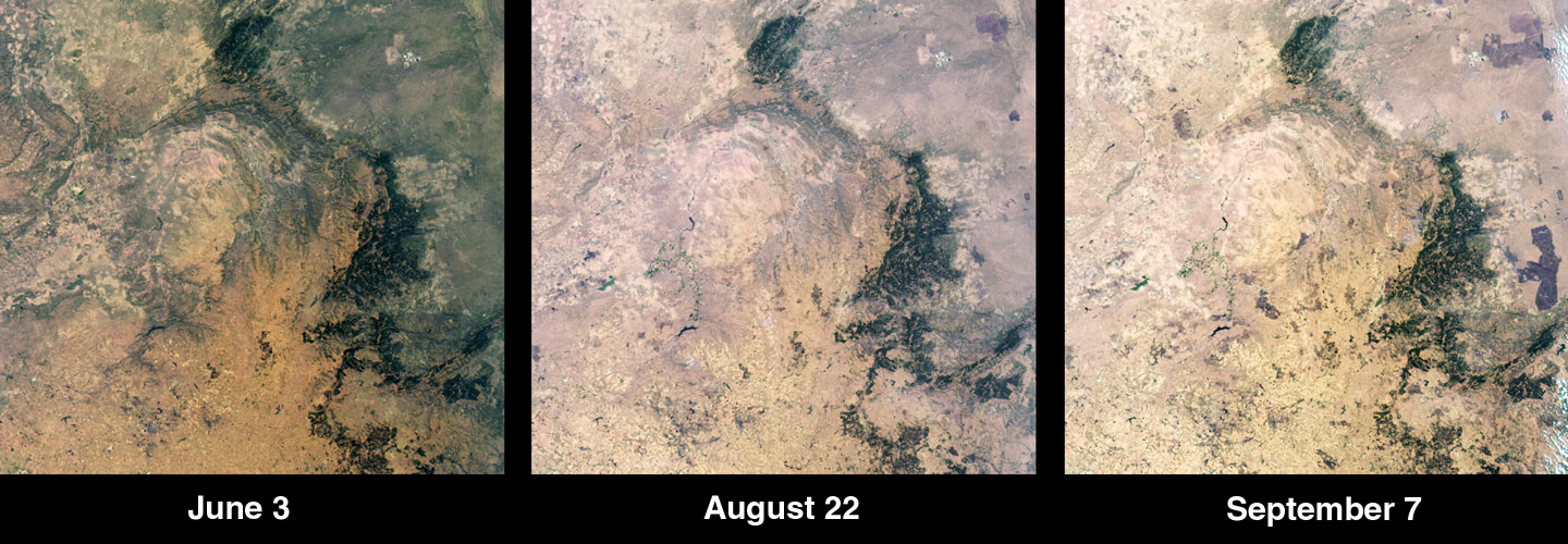 |
| A hazy day at Sua Pan, 03-Sep-00 | |
| These images of Sua Pan, Botswana, are from MISR's Ba (45.6 deg. aft) camera. The left image is from August 18 (Terra orbit 3553, Path 173). The right image is from September 3 (Terra orbit 3786, path 173). Both images have been processed using identical radiometric and color stretches. The increased haziness of the September 3rd image is apparent. This will be an interesting case study for the MISR Level 2 optical depth retrievals. | 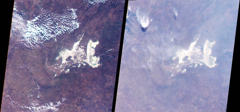 |
| Angola and Namibia, 30-Aug-00 | |
| MISR images of Angola and Namibia acquired on August 30, 2000 during Terra orbit 3728 (World Reference System-2 path 177). The left image is from the vertical-viewing (nadir) camera and the right image is from the 70.5-degree aftward-viewing camera. The oblique view enhances the effect of atmospheric haze and highlights the presence of smoke plumes from a large number of grassland fires. The area in the approximate center of each image is the Cuando Cubango province of southern Angola, including, from west to east, the Cubango, Cuito, and Cuando Rivers. The Cubango (also known as the Okavango) traces part of the border between Angola and Namibia, and terminates in northern Botswana in the swampy tract known as the Okavango Delta. The large, dark area near the top of the images is the Bie Plateau. Both the nadir and oblique images are on the same radiometric scale. |
 |
| Zambia and Botswana, 25-Aug00 | |
| View these images and captions of Zambia and Botswana on our MISR gallery page. |  |
| Southern Africa, 25-Aug-00 | |
| MISR images of Africa acquired on August
25, 2000, during Terra orbit 3655. The left image is a color view from
the vertical-viewing (nadir) camera. The right image is a color view from
the camera viewing 70.5 degrees aftward along the orbital track. The oblique
view angle accentuates the effect of the atmosphere, giving the image its
bluish cast and also enhancing the visibility of smoke plumes and haze.
The southern tip of South Africa is at the bottom of the image, and Zambia is at the top. Distinctive features about a third of the way from the top are the dark Okavango Delta on the left and the western tip of bright Ntwetwe Pan on the right. To the north of these an abundance of smoke plumes is visible. |
 |
| Aerosol retrieval over Cape of Good Hope, 23-Aug-00 | |
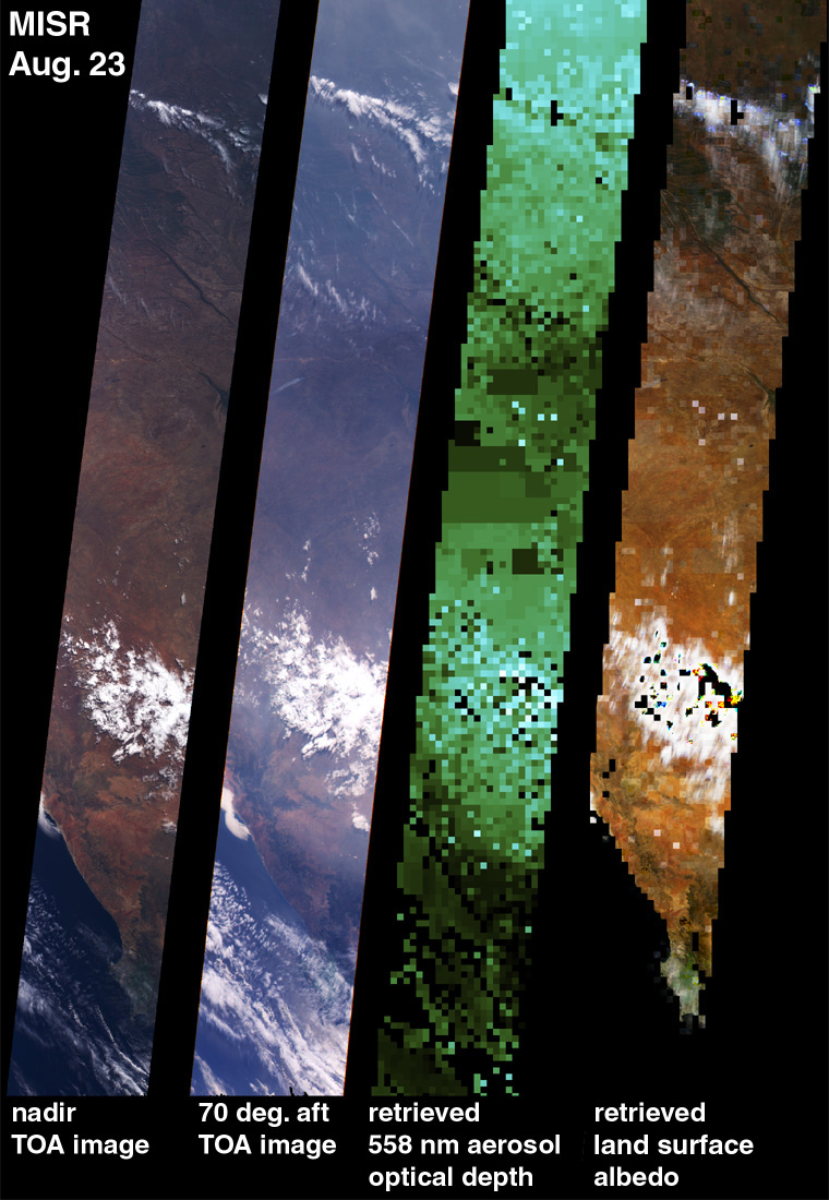
| This first of two image sets, with the
four strips, extends from 10 deg. S latitude to just south of the Cape
of Good Hope, and are each 40 0 km wide. The left image is a nadir top-of-atmosphere
(TOA) image, i.e., the Level 1 product. The image to the right of it is
the Da camera (70.5 deg. aft) Level 1 image. It shows the atmospheric and
aerosol scattering effect pretty well. The image right of that is the retrieved
aerosol optical depth at 558 nm, one of our Level 2 products. It captures
the general trend of the aerosol; in particular note what appears to be
a haze boundary in the Da image in the southern part of South Africa --the
aerosol retrieval picks it up, and also the slightly clearer area in the
middle. Also, what's very encouraging is that the optical depths on both
sides of the coastline are similar, despite coming from two completely
different algorithms (one is for land, the other for water). The cloud
screening is clearly not working entirely well. We are not using cloud
thresholding at this point--the cloud screening is being done using a criterion
that requires the terrain projected radiances to be a smooth function of
angle, for each pixel. Any cloud above the surface will misregister because
of parallax and therefore the radiance vs. angle should not be smooth.
But this algorithm fails for near-surface clouds and homogeneous, extensive
clouds. This will improve as we implement more code elements. The rightmost
image is retrieved land surface "bihemispherical reflectance", or albedo
for short, also a Level 2 product. It is an atmospherically-corrected product
--we remove ozone absorption, clear atmosphere (Rayleigh) scattering, and
scattering from the retrieved aerosol.
These data are all from orbit 3626, path 176, on August 23. |
 |
| Cape of Good Hope, enlargement, 23-Aug-00 | |
| This next image is an enlargement of the one above, showing a more detailed comparison of Level 1 imagery (from the Da camera) with the Level 2 retrieved surface albedo. The albedo is the ratio of the amount of radiant energy reflected by the surface into all angles, divided by the incoming energy, so MISR's contribution is not only the aerosol retrieval necessary to do the correction, but the multi-angular integration. The image is a red, green, blue composite. Note that the albedo is retrieved at 1.1-km resolution, but the aerosol is retrieved at 17.6-km resolution. This is why there is a slight "quilting" effect in the albedo product, and also some 17.6-km squares where the aerosol retrieval has obviously blundered. Again, more areas to keep working on, along with the imperfect cloud masking. |  |
| Ntwetwe and Sua Pans, Northeastern Botswana, Africa, 18-Aug-00 | |
| MISR images of the Ntwetwe and Sua Pans in northeastern Botswana, South Africa. The upper left image is a color view from the vertical-viewing (nadir) camera acquired on June 24, 2000. The upper right image is a nadir view from August 11, and the lower left is a nadir view from August 18. On the lower right is a composite of red band imagery from August 18 in which the 45-degree aft camera data are displayed in blue, the 45-degree forward as green, and vertical as red. This combination causes wet areas to appear blue because of the glint-like reflection from water and damp surfaces. See this also on the MISR gallery page. | 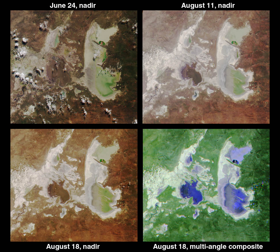 |
| Anagylph of Capetown, South Africa, 16-Aug-00 | |
| This is a stereo anaglyph. To view it you'll need a pair of stereo glasses (red for the left eye; blue for the right. In this image of Cape Town, South Africa, north is to the left.. This image if from Path 175, Orbit 3524. |  |
| Mosaic, 16 to 30-Aug-00 | |
| These mosaics from MISR's nadir (left) and 60-degree aftward-viewing camera (right) are comprised of data covering World Reference System-2 paths 165-179 for the period August 16 - August 30, 2000. The swath-by-swath Space Oblique Mercator imagery has been remapped onto a Geographic grid. Visible at the top are Saudi Arabia and portions of the Middle East, the Nile Delta, the southeastern corner of the Mediterranean Sea, and the Red Sea. Much of the African continent is contained within these composites. Africa is cloudier and greener in the equatorial Intertropical Convergence Zone, which runs through the middle of the images. South of the equator, extensive haze is visible, particularly in the oblique camera mosaic. Because these images are created from 400-kilometer wide orbital swaths acquired on different dates, discontinuities are visible where the clouds have moved between acquisitions. Both the nadir and oblique mosaics are on the same radiometric scale. |  |
Browse images are created by automated software, and are not optimized for photo quality. Their purpose is to provide an initial look at the data, to verify file content, and to obtain a visual estimate of cloud cover or other conditions at the time of the overpass. These images can be uploaded and manipulated in software such as Adobe PhotoShop to obtain a more aesthetically pleasing image. Thus was done to produce the captioned image shown above.
MISR collects data in image strips from high northern latitudes moving south to extreme southern latitudes. This pole-to-pole coverage is then broken down into 180 regions called blocks. The links that are of the form "Bnnn" open smaller jpeg images, about 150 kB each. These cover an area of 3 blocks, or 3 degress in latitude. The links that are of the form "Snnn" cover the entire southern Africa swath, from about 10 degress south latitude to 30 degrees south latitude (20 Blocks). The images are from a data product we call "L1B2 Ellipsoid". That is, the data have been resampled to put on a geographic reference grid.
| Date | Path | Orbit | DF | CF | BF | AF | AN | AA | BA | CA | DA | ||||||||||
|---|---|---|---|---|---|---|---|---|---|---|---|---|---|---|---|---|---|---|---|---|---|
| Sun 13Aug00 Pietersburg=B110 |
170 | 3480 | B109
S100 DAAC |
B109
S100 DAAC |
B109
S100 DAAC |
B109
S100 DAAC |
B109
S100 DAAC |
B109
S100 DAAC |
B109
S100 DAAC |
B109
S100 DAAC |
B109
S100 DAAC |
||||||||||
| Mon 14Aug00 | None | ||||||||||||||||||||
| Tue 15Aug00 Inhaca=B111 |
168 | 3509 | B109
S100 DAAC |
B109
S100 DAAC |
B109
S100 DAAC |
B109
S100 DAAC |
B109
S100 DAAC |
B109
S100 DAAC |
B109
S100 DAAC |
B109
S100 DAAC |
B109
S100 DAAC |
||||||||||
| Wed 16Aug00 Mongu=103 |
175 | 3524 | B103
S100 DAAC |
B103
S100 DAAC |
B103
S100 DAAC |
B103
S100 DAAC |
B103
S100 DAAC |
B103
S100 DAAC |
B103
S100 DAAC |
B103
S100 DAAC |
B103
S100 DAAC |
||||||||||
| Thu 17Aug00 | 166 | 3538 | S100
DAAC |
S100
DAAC |
S100
DAAC |
S100
DAAC |
S100
DAAC |
S100
DAAC |
S100
DAAC |
S100
DAAC |
S100
DAAC |
Fri 18Aug00 Sua Pan=B107 |
173 | 3553 | B106
S100 DAAC |
B106
S100 JPL |
B106
S100 DAAC |
B106
S100 DAAC |
B106
S100 JPL |
B106
S100 DAAC |
B106
S100 DAAC |
B106
S100 DAAC |
B106
S100 JPL |
| Sat 19Aug00 Walvis Bay=B109 |
180 | 3568 | B109
S100 DAAC |
B109
S100 DAAC |
B109
S100 DAAC |
B109
S100 DAAC |
ND | B109
S100 DAAC |
B109
S100 DAAC |
B109
S100 DAAC |
B109
S100 DAAC |
||||||||||
| Sun 20Aug00 | 171 | 3582 | S100
DAAC |
S100
DAAC |
S100
DAAC |
S100
DAAC |
S100
DAAC |
S100
DAAC |
S100
DAAC |
S100
DAAC |
S100
DAAC |
||||||||||
| Mon 21Aug00 Etosha=B105 |
178 | 3597 | B103
S100 DAAC |
B103
S100 DAAC |
B103
S100 DAAC |
B103
S100 DAAC |
B103
S100 DAAC |
B103
S100 DAAC |
B103
S100 DAAC |
B103
S100 DAAC |
B103
S100 DAAC |
||||||||||
| Tue 22Aug00 Skukuza=B110 |
169 | 3611 | B109
S100 DAAC |
B109
S100 DAAC |
B109
S100 DAAC |
B109
S100 DAAC |
B109
S100 DAAC |
B109
S100 DAAC |
B109
S100 DAAC |
B109
S100 DAAC |
B109
S100 DAAC |
||||||||||
| Wed 23Aug00 Mongu=B103 |
176 | 3626 | B103
S100 DAAC |
B103
S100 DAAC |
B103
S100 DAAC |
B103
S100 DAAC |
B103
S100 DAAC |
B103
S100 DAAC |
B103
S100 DAAC |
B103
S100 DAAC |
B103
S100 DAAC |
||||||||||
| Thu 24Aug00 Skukuza=B111 |
167 | 3640 | B109
S100 DAAC |
B109
S100 DAAC |
B109
S100 DAAC |
B109
S100 DAAC |
B109
S100 DAAC |
B109
S100 DAAC |
B109
S100 DAAC |
B109
S100 DAAC |
B109
S100 DAAC |
||||||||||
| Fri 25Aug00 Mongu=B103 Maun=B106 |
174 | 3655 | B103
B106 S100 DAAC |
B103
B106 S100 DAAC |
B103
B106 S100 DAAC |
B103
B106 S100 DAAC |
B103
B106 S100 DAAC |
B103
B106 S100 DAAC |
B103
B106 S100 DAAC |
B103
B106 S100 DAAC |
B103
B106 S100 DAAC |
||||||||||
| Sat 26Aug00 | 165 | 3669 | B109
S100 DAAC |
B109
S100 DAAC |
B109
S100 DAAC |
B109
S100 DAAC |
B109
S100 DAAC |
B109
S100 DAAC |
B109
S100 DAAC |
B109
S100 DAAC |
NV | ||||||||||
| Sun 27Aug00 Sua Pan=B107 |
172 | 3684 | B106
S100 DAAC |
B106
S100 DAAC |
B106
S100 DAAC |
B106
S100 DAAC |
B106
S100 DAAC |
B106
S100 DAAC |
B106
S100 DAAC |
B106
S100 DAAC |
B106
S100 DAAC |
||||||||||
| Mon 28Aug00
Walvis Bay=B109 |
179 | 3699 | B109
S100 DAAC |
B109
S100 DAAC |
B109
S100 DAAC |
B109
S100 DAAC |
B109
S100 DAAC |
B109
S100 DAAC |
B109
S100 DAAC |
B109
S100 DAAC |
B109
S100 DAAC |
||||||||||
| Tue 29Aug00 | 170 | 3713 | S100
DAAC |
S100
DAAC |
S100
DAAC |
NV | S100
DAAC |
S100
DAAC |
S100
DAAC |
S100
DAAC |
S100
DAAC |
||||||||||
| Wed 30Aug00 | None | ||||||||||||||||||||
| Thu 31Aug00
Skukuza=B110 |
168 | 3742 | B109
S100 DAAC |
B109
S100 DAAC |
B109
S100 DAAC |
B109
S100 DAAC |
B109
S100 DAAC |
B109
S100 DAAC |
B109
S100 DAAC |
B109
S100 DAAC |
B109
S100 DAAC |
||||||||||
| Fri 01Sep00
Mongu=103 |
175 | 3757 | B103
S100 DAAC |
B103
S100 DAAC |
B103
S100 DAAC |
ND | B103
S100 DAAC |
B103
S100 DAAC |
B103
S100 DAAC |
B103
S100 DAAC |
B103
S100 DAAC |
||||||||||
| Sat 02Sep00 | 166 | 3771 | DAAC | DAAC | ND | ND | ND | DAAC | DAAC | ND | DAAC | ||||||||||
| Sun 03Sep00
Sua Pan = B107 |
173 | 3786 | B106
DAAC |
B106
JPL |
B106
DAAC |
B106
DAAC |
B106
JPL |
B106
DAAC |
B106
DAAC |
B106
DAAC |
B106
JPL |
||||||||||
| Mon 04Sep00 Walvis Bay=B109 |
180 | 3801 | B109
S100 DAAC |
B109
S100 DAAC |
B109
S100 DAAC |
B109
S100 DAAC |
B109
S100 DAAC |
B109
S100 DAAC |
B109
S100 DAAC |
B109
S100 DAAC |
B109
S100 DAAC |
||||||||||
| Tue 05Sep00 | 171 | 3815 | NV | NV | NV | NV | S100
DAAC |
NV | NV | NV | NV | ||||||||||
| Wed 06Sep00
Etosha = B105 |
178 | 3830 | B103
B106 S100 DAAC |
B103
B106 S100 DAAC |
B103
B106 S100 DAAC |
B103
B106 S100 DAAC |
B103
B106 S100 DAAC |
B103
B106 S100 DAAC |
B103
B106 S100 DAAC |
B103
B106 S100 DAAC |
B103
B106 S100 DAAC |
||||||||||
| Thu 07Sep00
Kruger=B108:110 Skukuza=B110 |
169 | 3844 | B106
B109 S100 DAAC |
B106
B109 S100 DAAC |
B106
B109 S100 DAAC |
B106
B109 S100 DAAC |
B106
B109 S100 DAAC |
B106
B109 S100 DAAC |
B106
B109 S100 DAAC |
B106
B109 S100 DAAC |
B106
B109 S100 DAAC |
||||||||||
| Fri 08Sep00
Mongu=103 |
176 | 3859 | ND | B103
S100 DAAC |
B103
S100 DAAC |
B103
S100 DAAC |
ND | B103
S100 DAAC |
B103
S100 DAAC |
B103
S100 DAAC |
NV | ||||||||||
| Sat 09Sep00
Inhaca, Skukuza=B111 |
167 | 3873 | B109
S100 DAAC |
B109
S100 DAAC |
B109
S100 DAAC |
B109
S100 DAAC |
B109
S100 DAAC |
B109
S100 DAAC |
B109
S100 DAAC |
B109
S100 DAAC |
B109
S100 DAAC |
||||||||||
| Sun 10Sep00
Mongu=B103 Maun=B106 |
174 | 3888 | B103
B106 S100 DAAC |
B103
B106 S100 DAAC |
B103
B106 S100 DAAC |
B103
B106 S100 DAAC |
B103
B106 S100 DAAC |
B103
B106 S100 DAAC |
B103
B106 S100 DAAC |
B103
B106 S100 DAAC |
B103
B106 S100 DAAC |
||||||||||
| Mon 11Sep00 | 165 | 3902 | S100
DAAC |
S100
DAAC |
S100
DAAC |
S100
DAAC |
S100
DAAC |
S100
DAAC |
S100
DAAC |
S100
DAAC |
S100
DAAC |
||||||||||
| Tue 12Sep00
Sua Pan=B107 |
172 | 3917 | |||||||||||||||||||