|
||
From 12/7 to 12/11/98, Jim Conel and Mark Helmlinger collected field data at Rogers Dry Lake, California; part of the Edwards Air Force Base complex: http://afftc.edwards.af.mil |
||
Rogers Lake is also home to NASA's Dryden Flight Research Center: http://www.dfrc.nasa.gov |
||
The purpose of the experiment was to attempt an in-flight radiometric calibration of AirMISR, which flies on the ER-2 out of Dryden. See: http://www.dfrc.nasa.gov/airsci |
||
We wanted a clear day which was not too windy for take-off/landing the ER-2. We had limited success. Winds were generally strong on the ground, and as it turned out, aloft at ER-2 altitudes. Several flight lines were flown over us, in an attempt to assure target acquisition at all nine angles. |
||
Collecting data on the ground at the same time AirMISR passed overhead, we were hoping to be able to make a prediction of the radiance numbers which AirMISR should return for the scene we were in. Those radiance numbers could be compared (and may have, by now) to the camera response of AirMISR determined in the laboratory. All if these steps are part of understanding the physics of what MISR will measure from space. This experiment was carried out before the launch of Terra. More recent experiments of this type are now attempted at the same time Terra orbits over the target of interest, making logistics just a bit more challenging. |
||
Jim likens the logistics of such deployments to balancing pencils point-to-eraser. This was a two-pencil experiment, (The weather and the plane + instrument). After this experiment, once Terra was in orbit, we attempted three-pencil experiments, such as Lunar Lake in the summer of 2000. |
||
Mark's photos of the experiment & explanations |
||
| Our target site on the North end of the Lake | ||
| We laid out large blue tarps in an attempt to enable the rapid identification of just where in the image the site appeared. Note the RV to the left behind Jim's Expedition. Also visible are (from left to right) the Reagans, our MET station, PARABOLA, CIMEL, and MFRSR. This photo was taken facing East. Note the TV antenna extended on top of the RV. Five or six channels, and still nothin' on... |  |
|
| Really Big Tarps! | ||
| The two tarps were set up with a series of small white flags at regular 10m intervals between them, marking off ten AirMISR pixels as projected on the ground from the 20km altitude of the ER-2. The reflectance of each pixel-sized area between the tarps was determined for later comparisons to the values of actual AirMISR image pixels. The right pixels to use are picked out from the scene by looking for the tarps (a couple of darker pixels) in the image and selecting those image pixels between them. Photo taken from southern edge of south tarp looking north. | 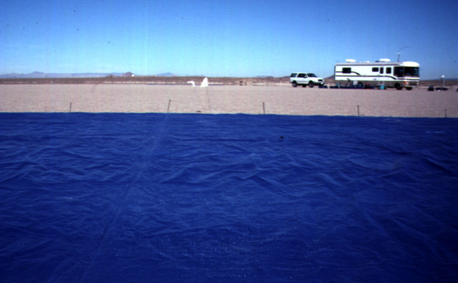 |
|
| Our MET station and friends | ||
| The instrument we use to collect meterological data is made by Davis and intended for home use. Not too accurate, but good enough. It all fits into the small blue crate at bottom. The cordwheels are stacked on it to keep it from blowing over. Also in the photo is Jim, messing around with PARABOLA, and our two Reagan sunphotometers. Note all of the solar panels used for powering PARABOLA and our laptop computers. That's 200W worth, right there. Photo taken from south of the RV, facing north-northeast in the afternoon. |  |
|
| Jim collecting PARABOLA F.O.V. data | ||
| On a non-overflight day we got creative. Using a sun-tracking stand, we collected solar radiance data with PARABOLA that can be used for sunphotometry. To investigate the actual field-of-view of the instrument in all bands for a 1/2deg near-point source, we stopped the tracking and continued to collect data as the sun moved out of the center of the FOV. Using accurate times and a solar ephemeris, we were able to analyze the data and correlate readings to how many degrees from center the sun had moved. Whaddya know - they taper off at just the FOV angle expected (5deg) - and sharply, too. |  |
|
| Our double-barreled CIMEL sunphotometer & sky radiometer | ||
| Taken looking towards the east, this photo shows Jim walking up to our CIMEL; #59 in a worldwide network of a couple hundred. It transmits its data to the Aeronet at GSFC (http://aeronet.gsfc.nasa.gov:8080/) and we can manually download it too. It characterizes sky radiance and solar irradiance in a very limited, but complete enough, fashion. I have heavily modified it to be campaign-oriented, rather than permanently installed at a site, as most are. PARABOLA can be seen behind Jim. |  |
|
| CIMEL in action | ||
| Every once in a while, CIMEL wakes up and looks about. Sometimes at the sun, sometimes around the sky. One sky scan is done at the elevation of the sun scanning all around in azimuth - an almercanter scan. Another type of sky scan is in the plane of the sun scanning in elevation - a principle plane scan. Jim watches as CIMEL takes direct solar beam data for optical depth. PARABOLA on its "fencepost" can be seen in the middle background. |  |
|
| Say cheese! | ||
| Barbara Gaitley of our Validation Team attempts to take a professional-quality photograph of the solar panels for one of our Reagan sunphotometers, despite the wind. Barbara came to visit during a non-overflight day and took several photos which have been the basis for many illustrations and posters about our validation efforts. Note the orange extension cords. One runs out to PARABOLA, and the other into the RV for laptops and charging batteries. I don't like running the clanky generator just for a few watts. |  |
|
| Now, if this crummy wind would die down... | ||
| Barbara tries to take a photo of CIMEL. Note the strap sticking out to the left of her. It is not a stiff strap, but it is heavy, and is being blown straight out by the wind! She is quite brave to climb up on that little ladder of hers... To the right of the RV in the background are a Reagan, the MET station, and another Reagan automatic sunphotometer, made by Dr. John Reagan's group at the University of Arizona. |  |
|