MISR Captures Hurricane Michael's Eye in 3D
On October 9, 2018, a Tropical Storm Michael in the Gulf of Mexico strengthened rapidly into a hurricane. Hurricane Michael was the second major hurricane this season to impact the United States, after Florence which caused major flooding in the Carolinas. Michael made landfall on the Florida panhandle on October 10 as a Category 4 storm on the Saffir-Simpson hurricane wind scale with sustained wind speeds greater than 130 miles per hour (209 kilometers per hour) and traveled northeastwards over Alabama, Georgia, and Carolinas. More than 3.8 million Florida residents were under hurricane warnings for winds potentially reaching 145 miles per hour, storm surges forecast for 9-14 feet, and up to 12 inches of rain.
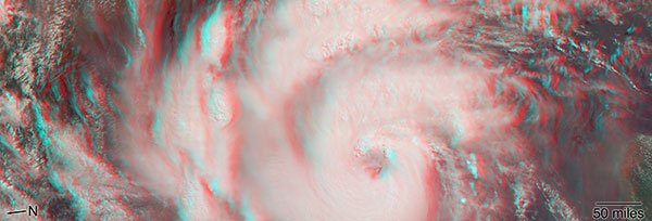
On October 9 at 12:30 pm Eastern Daylight Time, the Multi-angle Imaging SpectroRadiometer (MISR) instrument aboard NASA’s Terra Earth Observing System satellite passed over the eye of Hurricane Michael. MISR carries nine cameras fixed at different angles, each of which viewed Michael over a period of about seven minutes.
The 3D stereo anaglyph combines two of MISR's camera angles. You will need red-blue 3D glasses, with the red lens placed over the left eye, to see the effect.
At the time of MISR’s overpass, Michael was a Category 2 storm with sustained winds of 110 miles per hour (177 kilometers per hour). The eye was located approximately 300 miles (480 kilometers) southwest of Tampa, Florida. MISR’s wind data show that the cloud top winds near the center of the storm were approximately 70 miles per hour (110 kilometers per hour), and the maximum cloud-top wind speed throughout the storm was 90 miles per hour (145 kilometers per hour).
Apparent in the 3D stereo anaglyph are a number of bright “clumps.” These are groups of strong thunderstorms embedded within the hurricane. Known as “vortical hot towers,” these features indicate rapid transport of heat energy from the ocean surface into the storm, which usually accompanies a period of rapid intensification. In fact, between 11 am and 2 pm EDT, during which time MISR imaged the hurricane, the estimated central pressure dropped 8 millibars (8 hectopascals) and the maximum sustained winds increased about 12 miles per hour (19 kilometers per hour). Over the next 24 hours, Hurricane Michael intensified from a Category 2 to a Category 4 storm.
These data were captured during orbit 100049. MISR was built and is managed by NASA's Jet Propulsion Laboratory, Pasadena, California, for NASA's Science Mission Directorate, Washington, D.C. The Terra spacecraft is managed by NASA's Goddard Space Flight Center, Greenbelt, Maryland. The MISR data were obtained from the NASA Langley Research Center Atmospheric Science Data Center, Hampton, Virginia. JPL is a division of the California Institute of Technology in Pasadena.
Related Links