NASA's MISR Captures Hurricane Bonnie
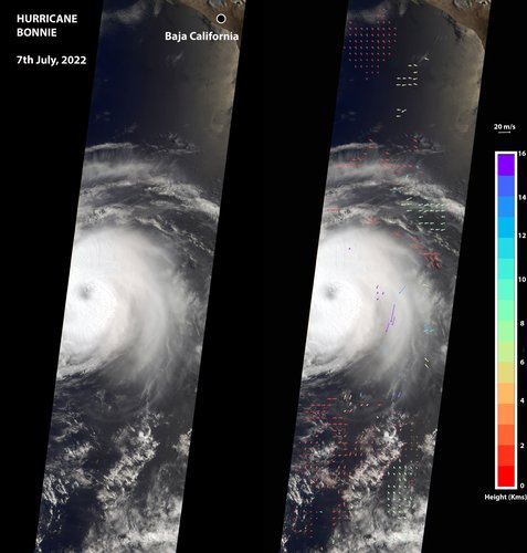
The Multi-angle Imaging SpectroRadiometer (MISR) instrument aboard NASA's Terra satellite captured this image of the eye of Hurricane Bonnie, located about 500 miles (800 kilometers) southwest of the southern tip of Baja California, Mexico, at about 11 a.m. local time on July 7, 2022. Initially classified as a tropical storm on July 2, Bonnie intensified to a Category 3 hurricane on July 5. It was later downgraded, and as of July 8, was considered a tropical storm.
MISR carries nine cameras pointed at Earth at different angles and each camera viewed Bonnie over a period of seven minutes. The motion of the hurricane between those views provides information on wind speed and direction at the height of the clouds. The panel on the left shows the image from MISR's downward-pointing camera. The colored arrows in the panel on the right, superimposed on the same image as the left panel, show wind speed and direction.
The length of the arrows is proportional to wind speed, and their color shows the altitude of the cloud tops in kilometers. MISR observed winds blowing counterclockwise at about 34 mph (55 kph) at altitudes of 6,500 to 33,000 feet (2 to 10 kilometers), consistent with maximal wind gusts reported by the National Hurricane Center based on data from local weather stations and buoys. At altitudes of about 36,000 to 52,000 feet (11 to 16 kilometers), MISR observed winds blowing clockwise at up to 123 mph (198 kph). The eye, spiral rainbands, and reversal of wind direction between low and high altitudes are typical features of a hurricane.
MISR was built and is managed by NASA's Jet Propulsion Laboratory in Southern California for the agency's Science Mission Directorate in Washington. The Terra spacecraft is managed by NASA's Goddard Space Flight Center in Greenbelt, Maryland. The MISR data was obtained from the NASA Langley Research Center Atmospheric Science Data Center in Hampton, Virginia. JPL is a division of Caltech in Pasadena.
Image Credit: NASA/GSFC/LaRC/JPL-Caltech, MISR Team