From the Field: ImPACT Measures Air Pollution Over California’s Central Valley
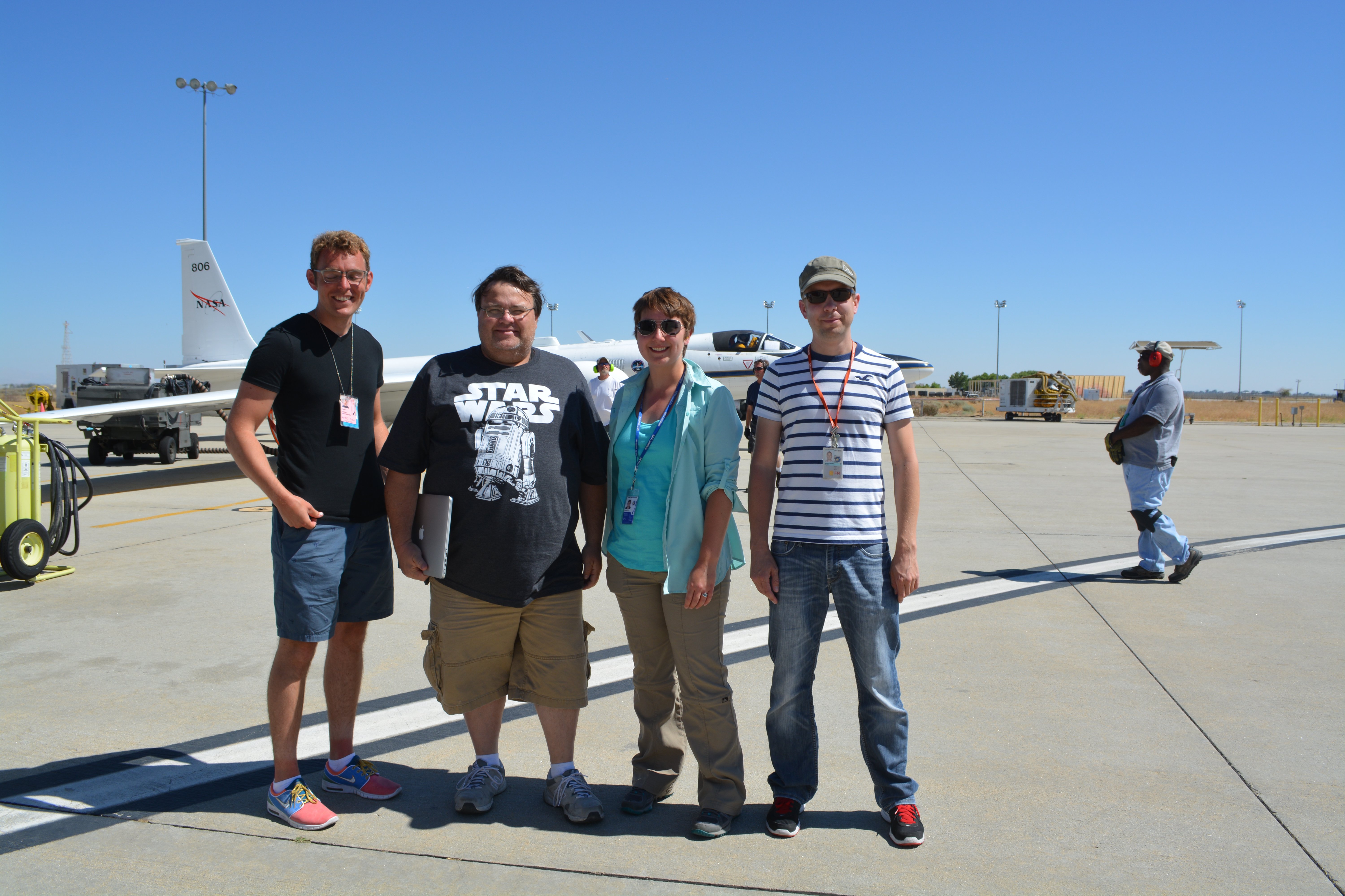
Some members of the ImPACT-PM team in front of the ER-2 (pilot Stu Brocce is visible in the cockpit). From left to right: Gerard van Harten, Brian Rheingans, Abbey Nastan and Felix Seidel. Image credit: Carol Bruegge.
July 5th dawns over the Los Angeles basin, bright and unusually clear. Like many others overtired after a night of celebration and fireworks, I yawn as I dress for work—but in zip-off pants and a wide-brimmed hat, I look more properly attired for a day of hiking than a day at the office. I am on an expedition of sorts, but my destination is a parking lot in Palmdale, and thankfully I don’t have to hike there: I catch a ride with Carol Bruegge, one of my coworkers at the Jet Propulsion Laboratory. As we pull in to Armstrong Flight Research Center, I catch a glimpse between the hangars of a small white aircraft with long, thin wings. This is one of NASA’s ER-2 high altitude research planes, and it is central to ImPACT-PM, a flight campaign I have been recruited for as a member of JPL’s Multi-angle Imaging SpectroRadiometer (MISR) team.
ImPACT-PM (Imaging Polarimetric Assessment and Characterization of Tropospheric Particulate Matter) is all about measuring air pollution via remote sensing. The hazy layer of pollution that besmirches heavily populated areas—and sometimes blows to places far from population centers—is actually made up of tiny particles of smoke, dust, soot, and chemical-laden water droplets. This particulate matter, or PM, is small enough to be inhaled into your lungs, increasing your risk for certain cardiovascular and respiratory diseases like asthma and heart disease. The problem is that the constituents of PM are routinely monitored by only a very sparse network of ground stations, which makes it hard for scientists and health professionals to figure out which types of PM contribute to which health problems.
Sensors on the ground or flying at low altitude collect PM directly and sort it into types using various filters, but they provide information only where they are installed or flown. High-altitude airborne and satellite instruments can collect data on a global scale, but since these instruments fly far above the pollution, they cannot sample it directly. Until recently, remote sensing measurements have been confined to the total concentration of PM and estimates of its size and shape based on how a layer of haze reflects light. Some types of PM are round because the constituent chemicals are dissolved in liquid water droplets, while others are very jagged (such as dust particles). The various sizes and shapes of airborne particles makes sunlight scatter differently off them. The MISR instrument, which orbits the Earth on NASA’s Terra satellite, uses nine cameras pointed at different angles to gather this type of information about air pollution, but the results it can provide are limited.
Today, the JPL team is heading out to test new methods of characterizing the various components of airborne particles. A key sensor in the experiment is an instrument called AirMSPI (Airborne Multi-angle SpectroPolarimetric Imager), which will be flying aboard the ER-2. AirMSPI was built under the supervision of JPL senior scientist Dave Diner and adds to the multiple-view angle capabilities of MISR with the ability to view light in ultraviolet and infrared, as well as capturing information about polarization. The polarization of light is what allows sunglasses to cut out glare and lets us watch movies in 3D, and AirMSPI uses very sensitive polarization measurement technologies. An instrument that measures the brightness, color, angular distribution, and polarization of light reflected off of airborne particles can make a much better estimate of their physical properties than just one of these techniques by itself. However, even all of these measurements together are not enough to definitively categorize their chemical composition. In order to bridge the gap, JPL scientists plan to enlist the help of powerful chemical transport models that predict how different types of PM, from diverse sources such as factory smokestacks or wildfires, move around the globe.
Recognizing the importance of connecting PM to health, NASA has recently selected JPL’s proposal for an instrument named MAIA (Multi-Angle Imager for Aerosols) to be launched into low-Earth orbit. Using capabilities similar to AirMSPI, it will monitor PM in several major cities around the world, including ones with very poor air quality. But before MAIA launches, the team needs data to study how well their remote sensing + chemical transport model method works—and this is where AirMSPI and ImPACT-PM come in. Olga Kalashnikova, a senior researcher on the MSPI team, has picked California’s Central Valley as the perfect place to act as a testbed: cities like Fresno, Modesto and Bakersfield have perennial problems with air pollution. She has scheduled this campaign right after the Fourth of July, hoping the wildfire season and fireworks ephemera would provide interesting data.
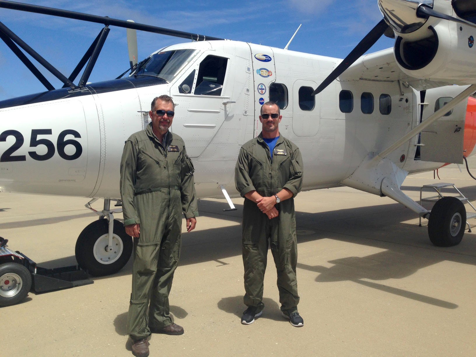
Pilots Marko Jaakkola (left) and Bryce Kujat (right) pose with the Twin Otter plane in Monterey. Image credit: Olga Kalashnikova
In collaboration with her co-principal investigator of the ImPACT-PM campaign, Professor John Seinfeld of Caltech, Olga has pulled together a suite of twenty-five scientific instruments: some flying on the ER-2, others on a Twin Otter airplane, MISR on Terra, and still more stationed on the ground throughout the Central Valley. These instruments will work together to check each other’s answers on the amount and composition of air pollution they measure. Olga and John must coordinate with the twenty-odd scientists, pilots, and crew from various organizations in order to get everything in the right place, at the right time, working correctly.
As Carol and I enter the massive hangar, bedecked with American flags and the NASA logo, we encounter AirMSPI flight scientist Felix Seidel. His task is to plot the course that the ER-2 will fly over the Central Valley and to let the pilot know when to press the cockpit switches that activate AirMSPI’s computerized data collection sequences. Outside the hangar, pilot Donald “Stu” Broce has already fired up the engines on the ER-2. Stu is a retired Air Force and Navy pilot who now uses his exceptional abilities in the name of science. Alone in the cockpit, Stu must both fly a complicated course down to the second and perform all of the tasks needed to target and run the scientific instruments. As we approach the plane, AirMSPI chief engineer Brian Rheingans hands me a pair of earplugs. He and postdoc Gerard Van Harten are in charge of AirMSPI instrument operations. Last week, while they were mounting the instrument into the nose cone of the plane, the rubber O-ring that seals the hole in the cockpit slipped out and snapped. Unfortunately, all of the spare parts had already been shipped to Africa for the next campaign. Luckily, they were able to have a new O-ring delivered overnight, and AirMSPI is set for today’s flight.
As we wait for takeoff, Felix shows me a picture Olga sent to him of the Twin Otter piloted by Marko Jaakkola and Bryce Kujat which already took off from Monterey. In contrast to the ER-2, the Twin Otter will fly in spirals over the targets, while its suite of Caltech instruments collects information about the PM at various altitudes. ImPACT-PM co-principal investigators Olga and John are stationed at Monterey in order to monitor the results coming in from the Caltech instruments and change the flight plans if necessary. We watch the ER-2 taxi out of sight, followed by an escort car and life support RV. A few minutes later, we hear the roar of the engines and the plane leaps above the base, climbing as steeply as if Stu was once again taking off from an aircraft carrier. Just a few seconds later, Martijn Smit, head of the airSPEX instrument team from the Netherlands, is already on the phone. AirSPEX is another polarization-sensitive instrument installed in the ER-2. The takeoff seems to have disrupted his instrument’s internal clock, which is critical to ensure it takes data at the right time. While he works with his team to fix the problem, the rest of us watch the plane rapidly disappear, heading for a cruising altitude of 65000 feet (nearly 20 km, twice as high as a commercial airliner!).
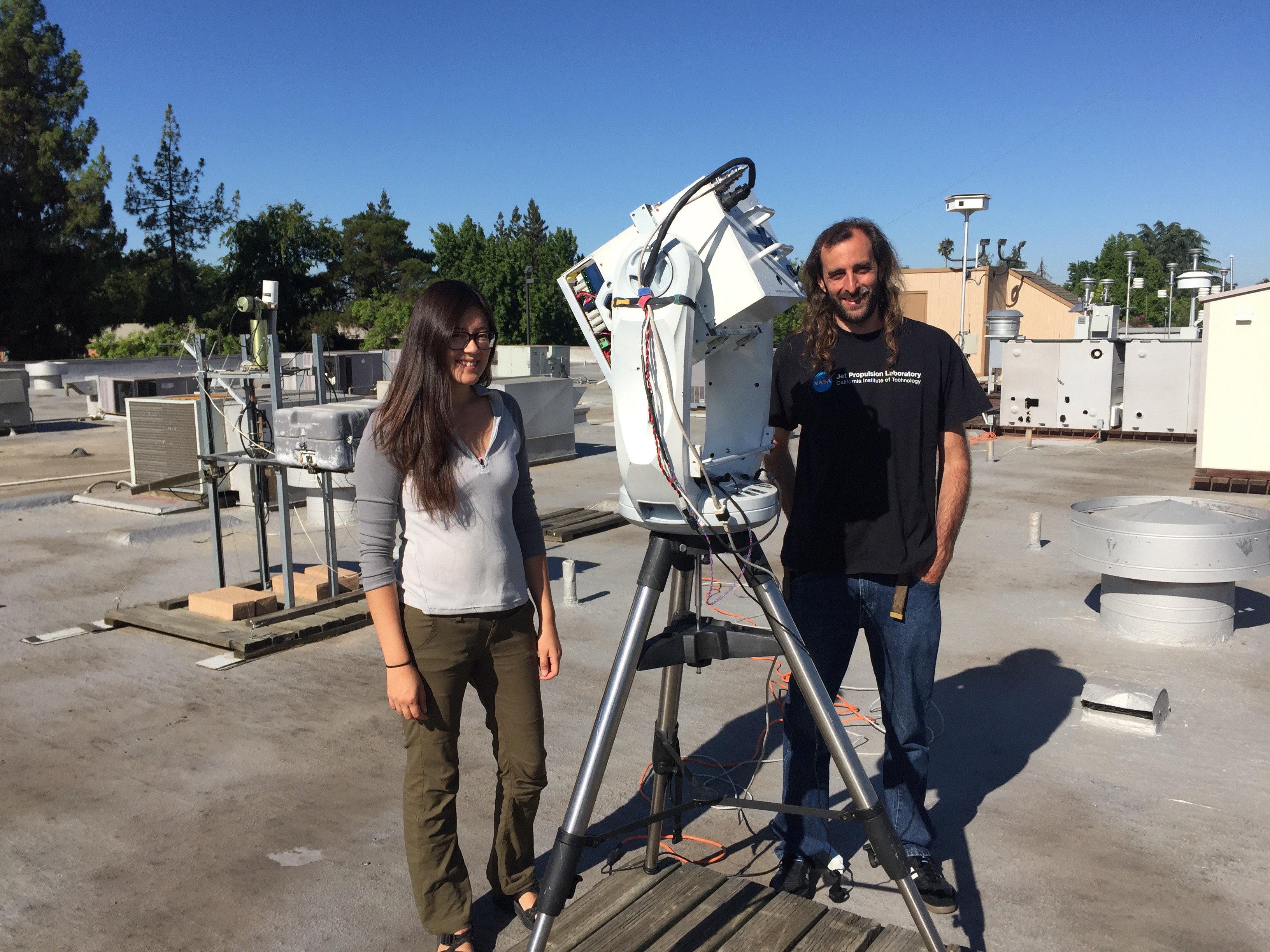
The team in Fresno: Christine Bradley (left) and Sebastian Val (right) with GroundMSPI on the roof of the Fresno EPA building. Image credit: Scott Scheller.
Back inside the hangar, everyone settles down in the science instrument lab to view the instrument status data streaming in from the ER-2. Across from me, John Yorks monitors the Cloud Physics Lidar (CPL) instrument supplied by Goddard Space Flight Center, while Brian Rheingans shows me how to follow the ER-2’s progress on the NASA Airborne Science Public Tracker (mts.nasa.gov). Already, Stu, Marko and Bryce are preparing to make the first coordinated overpass over Fresno. There, on a rooftop in downtown, a small team awaits the time to begin their ground measurements. While the planes fly overhead, graduate student Christine Bradley of the University of Arizona and Sebastian Val of JPL scan the sky with GroundMSPI, a prototype of its airborne companion, which is perched atop a Celestron telescope mount. Next to them, NASA and EPA-operated instruments constantly measure the concentration of particles in the atmosphere. Together all these data will help show whether AirMSPI data analysis calculates the right concentrations of PM.
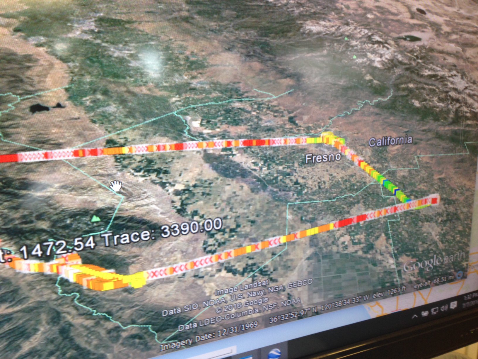
Real-time results from the CIRPAS instruments aboard the Twin Otter plane are displayed overlain on Google Earth imagery. Image credit: Olga Kalashnikova.
The planes move on to Modesto, while in Monterey, Olga and John review the data just collected over Fresno. There is not much pollution there today, and there are three more passes of Fresno scheduled for later in the day. In a bid to get some more interesting data, Olga asks Sebastian to jump in his car and drive to Clovis, nine miles north, to gather data with a portable instrument called a Microtops. At the same time, Carol receives word that the EPA’s AERONET station in Modesto is not working. Despite the setback, the ER-2 and the Twin Otter go ahead with their measurements over the city. On his way back from Modesto, Stu will fly directly under the path of MISR on Terra, orbiting 705 km above the Earth. This gives the team yet another set of data to compare with AirMSPI’s.
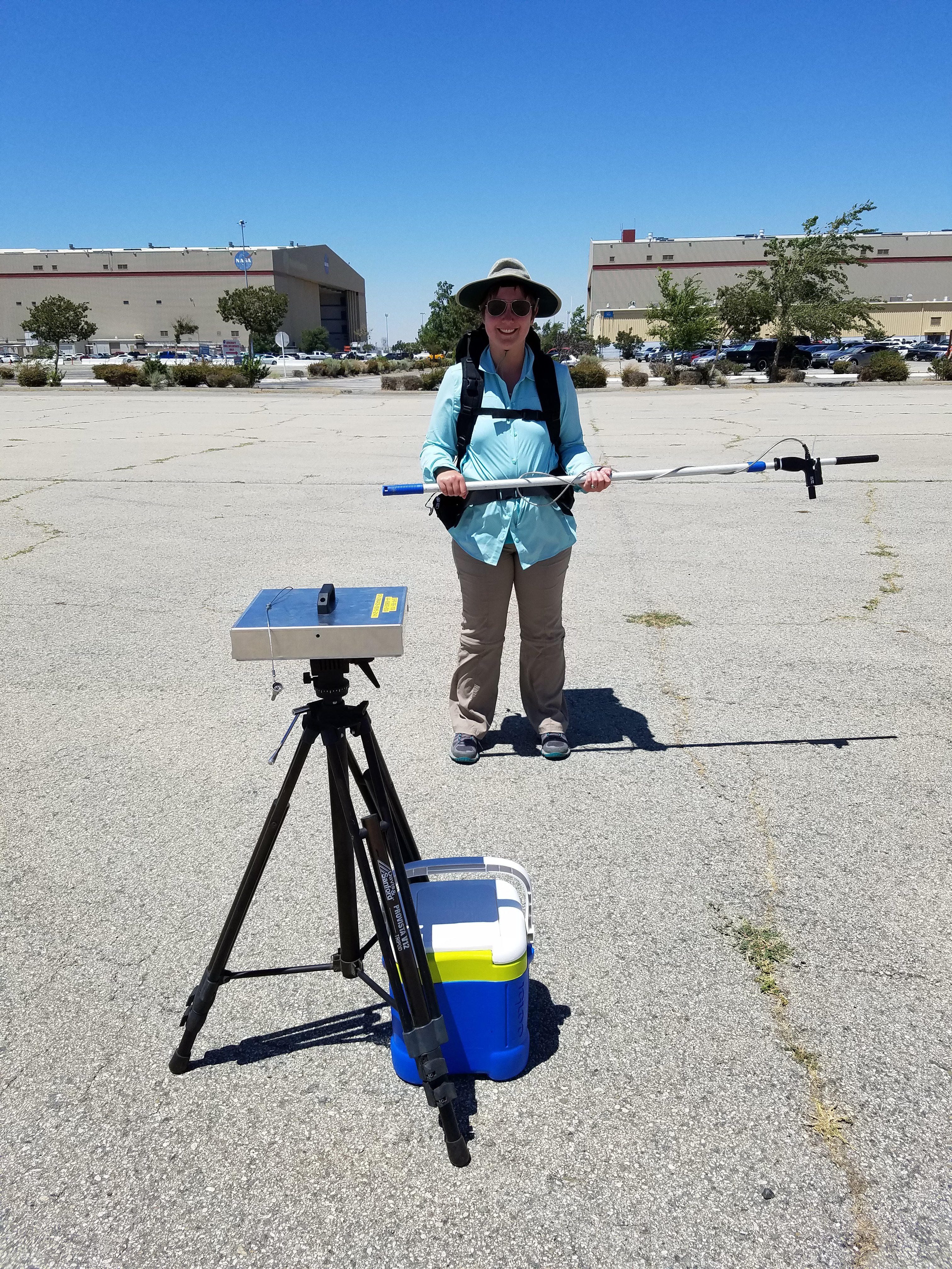
Abbey Nastan with the portable spectrometer (in the backpack) and its targeter. In the foreground is the piece of Spectralon (under the silver cover) and in the background is the NASA Armstrong Air Research Center hangar.
While Stu loops down to Bakersfield and back to Fresno, Carol and I leave the comfort of the hangar for a corner of the hot, windy parking lot. This deserted patch of asphalt, complete with weeds thrusting through the cracks, plays a critical role in Carol’s specialty: instrument calibration. Together, we unpack a portable spectrometer and buckle it into a backpack. A fiber optic cable snakes from the instrument to a pistol-like targeter, which we strap onto an ordinary pool pole to get it as far as possible from our bodies. Then we set up a piece of Spectralon—a special standard material that reflects light in a very precise way—on a tripod.
In twenty minutes, the ER-2 will fly directly overhead. I wear the backpack and point the pool-pole targeter at the asphalt while marching slowly around the parking lot. Behind me, Carol carries a laptop, prompting the spectrometer to store data every few seconds. Every few minutes we take data of the Spectralon for reference. At exactly 2:25 PM, we hear the distant roar of the plane and look up to see the tiny white craft in the deep blue sky, with a contrail streaming behind it. The data taken by AirMSPI of this nondescript parking lot, compared with the data Carol and I are taking on the ground, allows AirMSPI data to be accurately adjusted to correct for any variations in the instrument. While Stu flies on to loop around and land, we continue to take data for another twenty minutes.
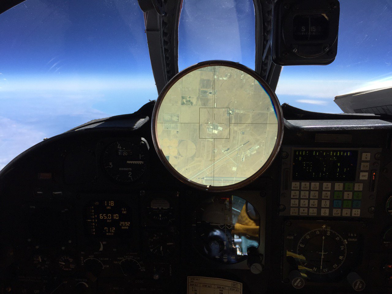
A view of the cockpit of the ER-2, showing the targeting instrument centered on the parking lot at Armstrong Air Research Center. Image credit: Stu Brocce.
After we pack up, we receive word that Stu has landed. Later, he sends us a picture he took of his targeting instrument in the ER-2 cockpit as he flew over Armstrong, showing the parking lot. Carol and I and the spectrometer are somewhere down there, though even magnified many times we are too small to see. Apart from the hiccup with the Modesto AERONET station, everything has gone exactly to plan—certainly a success in the uncertain world of field campaigns. There are two more flights scheduled this week, and the ImPACT-PM teams will decide to track down several fires and collected data on the smoky pollution. For today, though, the type of calibration exercise Carol and I completed only needs to be performed once per campaign, so we head back to Pasadena. The next day I will pack away my hat and zip-offs: just another day at the office.