A Portrait of Earth
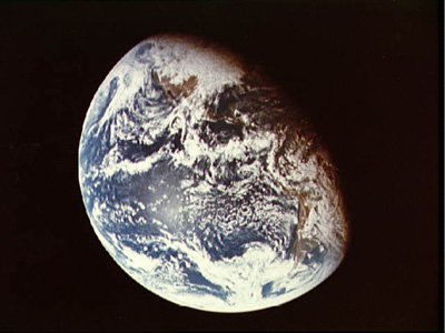
View of Earth as photographed by the Apollo 8 astronauts during their lunar orbital mission. North is about five percent to the right of vertical center. The sunset terminator crosses North America and South America. Clouds cover most of the United States. Only the desert southwest and Florida are clear.
NASA Photo ID: AS08-16-2596
by Ralph Kahn, February 1998
NASA is painting a new portrait of Earth. The one that hangs above the mantel now has been there nearly 30 years. It is a photograph taken by the Apollo 8 astronauts on their way to the moon, as they watched our planet shrink to a lonely blue-and-white marble in the blackness of space.
That single image still reminds us how rare the conditions are that make our tiny planet habitable. But as concerns deepen about natural and human-induced changes in those conditions, we want a picture of Earth that is more specific about what is happening to the climate, which after all is what makes the planet habitable.
The picture must contain details. The blended shapes of Apollo 8's photographic landscape will give way to the meticulous dots of a pointillist painting. Precisely where are deserts encroaching on grasslands? In what regions is it raining more than usual? Exactly how much are glaciers shrinking, and at what rate is the sea level rising?
Because environmental changes seldom occur in isolation, the new portrait of Earth has to depict a whole matrix of causes and effects. In the streets of Singapore this past autumn, people choked on the smoke from forest fires in nearby Indonesia. Fire-enhancing droughts in Indonesia occurred because rain clouds that usually drench the region had instead spread eastward, into the central Pacific. The rain clouds form above a huge pool of warm Pacific water that normally is pushed toward Indonesia by seasonal winds; last year these winds failed to strengthen.
The current El Niño created this web of interactions: Clouds, winds, ocean temperatures, forest fires and rainfall must all be measured to understand such phenomena.
Single snapshots, even if they cover the entire planet, won't do. Rainfall and temperature vary from day to day and year to year even under normal circumstances. Detecting changes in Earth's climate means answering questions such as: Are there places where "hundred year" floods have actually been taking place every five to seven years? Observations must be made frequently, and over many years.
To create a picture of the changing climate, we need to look everywhere, in detail, and often. But Earth is enormous, as anyone who has survived the flight from Los Angeles to Tokyo knows. Even if the area covered by each measurement of vegetation amount or cloud occurrence is as big as Dodger Stadium, it would take more than 1 million such observations to fill Southern California from Santa Barbara to San Diego. And for just one narrow band of Earth, from pole to pole, you'd need a strip composed of 91 Southern California-size areas.
The new portrait will not fit on any canvas. To produce it, NASA has commissioned a whole series of Earth Observing System satellites. The first, EOS-AM, is scheduled to be launched this summer. When the instruments aboard the satellite are turned on, they will generate data so fast that receiving them all will be like acquiring a new Los Angeles phone book (White Pages) every two seconds--30 books per minute--24 hours a day.
About every seven weeks, the satellite archives will receive as much data from EOS-AM as are held in all the volumes of the Library of Congress. And the EOS-AM satellite alone is supposed to keep pouring numbers down from the sky, relentlessly, for at least six years.
It will be impossible to take in the entire portrait of our planet at once. Like viewers of a painting by French pointillist Georges Seurat, we will step back to get an overview, then focus in on an interesting detail. From a distance, we'll examine summaries that merge individual measurements into a manageable global picture.
We may use computers to create a series of such pictures taken over many seasons, and animate them, like flipping through a deck of cards, to see how things change.
Up close, we'll look at relationships among temperature, surface conditions and cloud types before returning to the big picture to see how the details in that region compare with those from other locations. Then we'll concentrate on places where things appear to be unusual.
And all the measurements will be archived. Researchers in the future will use them to examine long-term trends, and as a source of examples for testing new theories about how the atmosphere, ocean and land surface interact to produce climate.
A new portrait of Earth will hang above the mantel, but the wall holding it will have to be reinforced, and grasping the picture's message will take more than a casual glance.
Ralph Kahn is a Jet Propulsion Laboratory research scientist and participant in the EOS project who writes about Earth and space science issues.
Copyright © 1998 by R. Kahn. All rights reserved.
This article first appeared in the Los Angeles Times, Thursday, February 26, 1998