MISR's Viewing Geometry and Scattering Angles
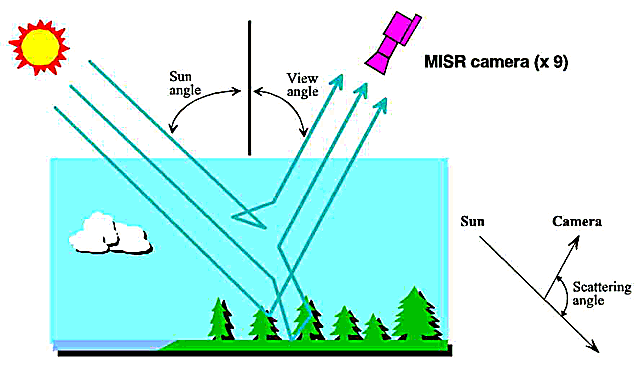
Viewing Geometry for a Satellite Camera
MISR has 9 cameras so the instrument can view Earth at this number of angles simultaneously. Most of the information about aerosol and cloud particle properties, and some of the information about surface structure, come from studying observations taken at different scattering angles.
Click the image below to see a diagram illustrating the geometric relationship between the sun, Earth's surface and atmosphere, and any one of the MISR cameras. The diagram shows where the scattering of light occurs. Remember that the true situation is 3-dimensional.
Scattering Angles
The scattering angle is the angle between the sun's direction and the viewing direction (see the Viewing Geometry section above.) Most of the information about cloud and dust particles in the air, and much of what remote sensing instruments can learn about the surface, comes from studying observations taken at different scattering angles. Click the image below to see an enlarged diagram illustrating the range of scattering angles that are observed by the 9 MISR cameras.
The scattering angles MISR observes are different for each camera, and also changes with the geographic latitude of the spacecraft (vertical axis in the figure) and the location across the MISR image (horizontal axis.) Each scan is about 400 km wide. This illustration shows the situation for March 21 and the nominal EOS-Terra spacecraft orbit. Imaging extends to 82 degrees latitude, and in some seasons folds over towards 60 degrees in the opposing hemisphere. The pattern remains nearly the same, but shifts poleward, as the solstice seasons approach.
MISR is unique as a spacecraft instrument because it covers such a wide range of scattering angles.
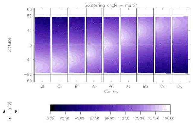
This diagram illustrates the range of scattering angles that are observed by the 9 MISR cameras.