News
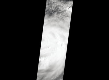
Oct. 4, 2016
NASA's MISR instrument catches hot towers -- enormous thunderheads -- from Hurricane Matthes over Haiti the morning of Oct. 4, 2016.

Sept. 12, 2016
In August 2016, the return of sunlight on the Antarctic Peninsula meant that the landscape became visible again in natural-color satellite imagery. That’s when scientists saw something interesting...
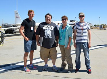
Sept. 10, 2016
ImPACT-PM (Imaging Polarimetric Assessment and Characterization of Tropospheric Particulate Matter) is all about measuring air pollution via remote sensing.
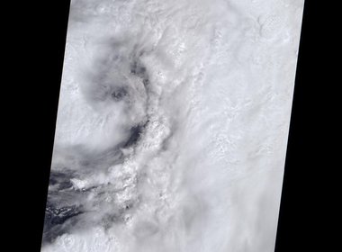
Sept. 1, 2016
This natural-color image from MISR's vertical-pointing camera shows the large, loosely organized hurricane. On Sept. 1, at 12:30 p.m. EDT, the center of the storm was located about 200 miles (325 kilometers) to the west of Sarasota on the Florida coast.
Aug. 25, 2016
Just in time for the U.S. National Park Service's Centennial celebration on Aug. 25, NASA's Multiangle Imaging SpectroRadiometer (MISR) instrument aboard NASA's Terra satellite is releasing four new anaglyphs that showcase 33 of our nation's national park
Oct. 7, 2015
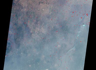
Every year, subsistence farmers set fire to the savannas and outlying tropical forests of Africa. All together, the carbon emissions from these fires account for 50% of the total global fire emissions in any given year.
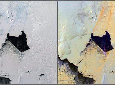
Nov. 15, 2013
The MISR instrument onboard NASA's Terra satellite passed over the Pine Island Glacier in Antarctica around Oct. 27, 2013, just days before Iceberg B-31 broke completely free. B-31 is finally moving away from the coast, with open water between the iceber
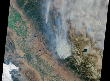
Sept. 4, 2013
MISR image reveals extensive, brownish smoke emanating from the fire, on August 23, 2013.
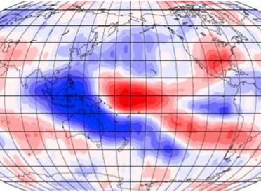
Feb. 23, 2012
The sky is falling … sort of. Over the last 10 years, the height of clouds has been shrinking, according to new research.

Feb. 22, 2012
Earth's clouds got a little lower -- about one percent on average -- during the first decade of this century, finds a new NASA-funded university study based on NASA satellite data.

Oct. 6, 2010
A unique partnership between NASA and agencies in Africa and Europe has sent more than 30 terabytes of free Earth science satellite data to South African researchers to support sustainable development and environmental applications in Africa.

Sept. 22, 2010
In many developing countries, the absence of surface-based air pollution sensors makes it difficult, and in some cases impossible, to get even a rough estimate of the abundance of a subcategory of airborne particles that epidemiologists suspect contribute

Sept. 15, 2010
MISR data were used to measure the concentration of aerosol pollutants over the Indian subcontinent and how it varies by season.

Sept. 1, 2010
With the peak of the 2010 Atlantic hurricane season still 10 days away, the relative calm of the first half of the season has quickly evaporated.

Sept. 1, 2010
Various images and animations of Hurricane Earl from August 29 to September 1, 2010.

Aug. 20, 2010
In late July 2010, flooding caused by heavy monsoon rains began across several regions of Pakistan.

Aug. 18, 2010
Various images of the Pakistan flood disaster from July 9 to August 18, 2010.

June 2, 2010
By combining data from multiple cameras of JPL's MISR instrument on NASA's Terra satellite, scientists gain new perspectives on the spread of oil into Louisiana's fragile wetlands.

May 20, 2010
New Gulf oil spill images from the Multi-angle Imaging SpectroRadiometer instrument on NASA's Terra spacecraft paint dramatic portraits of different aspects of the growing spill.

May 11, 2010
JPL instruments and personnel are among the NASA assets being used by U.S. disaster response agencies to assess the spread and impact of the oil spill in the Gulf of Mexico.