Spatial Resolution

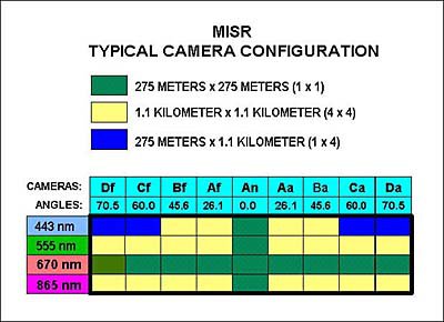
As explained in the main text, MISR can be configured for several different resolutions on the ground, camera by camera and spectral band by spectral band. The above diagram illustrates a typical configuration that might be used for Global Mode, i.e., for global coverage of Earth.
How does MISR view the ground?
Each MISR camera sees instantaneously a single row of pixels at right angles to the ground track, -- we call it a "pushbroom" imager because of the way it sweeps along the ground track. MISR collects data only on the daylit side of the Earth. During each orbit, MISR obtains a swath of imagery that is about 400 km wide by about 20,000 km long.
What is the reason for the swath width?
Changes in the reflectance of Earth's surface during the vegetation growing season are observable on weekly time scales. In accordance with this, the selected MISR viewing swath width of about 400 km allows viewing the entire Earth's surface in a period of 9 days, -- very close to one week.
What is the spatial resolution of the MISR images?
Since many physical phenomena, such as the lateral diffusion of radiation within aerosol layers, have characteristic horizontal scales on the order of 1 km, sub-kilometer resolution is required to resolve these scales. The intrinsic crosstrack dimensions of the MISR pixels was therefore chosen to be 275 meters at all off-nadir angles. For reasons of economy, the nadir camera makes use of the A camera design, resulting in a slightly higher crosstrack resolution of 250 meters, and this allows it to provide a slightly better ground locating reference that is passed on to the observations from the other cameras.
The time between acquisition of successive lines of MISR data (the line repeat time) is the same for all cameras, with an average of 275 meters of downtrack displacement. For the 705 km orbit, this requires a repeat time of 40.8 milliseconds.
What is Local Mode?
MISR is capable of taking image data in two different spatial resolution modes. In Local Mode, selected targets 300 km long are observed at the maximum resolution of 275 meters (pixel to pixel) in all cameras (250 meters across track for the nadir camera.)
However, the data transmission rate would be excessive if the instrument worked continuously at this maximum resolution. Therefore, away from these selected targets (there will typically be only 6 of these each day) the instrument operates in what is termed Global Mode, where Earth is observed continuously at lower resolutions. This is achieved by averaging the adjacent samples (in both the cross-track and along-track directions on the ground.) This averaging can be either 4 x 4, 1 x 4, or 2 x 2 pixels, and can be individually selected for each camera and spectral band.